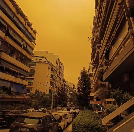
African dust makes Athens sky orange
- Written by E.Tsiliopoulos
African dust and high temperatures yesterday created an eerie scene reminiscent of a science fiction film and reminded nothing of the famed Attic skies of Athens..
The atmosphere may have been sultry yesterday, but today is expected to be better, although the combination of dust and high, for the season, temperatures will keep the background looking ... orange.
The American NASA Aqua satellite that passed over Greece on Tuesday morning (23/4), showed in high resolution the intense wave of African "Minerva red" dust that took place in the Eastern Mediterranean region, affecting to a very large extent Greece.
The low barometric front in the Sirte area of Libya moving towards Greece carried very large amounts of African dust making the air quality very heavy, presenting an eerie scene with a red sky.
Very high temperatures were recorded in areas of Southern Greece and especially in Crete, where the highest temperature was recorded in Falasarna of Chania with a value of 36.6°C.
According to his forecast, the African dust will start subsiding, but the phenomenon will remain in effect, at least until noon.
Today, Wednesday, April 24, improved weather is expected across the country. Concentrations of Saharan dust in the atmosphere will be increased, but progressively the dust will move further east and be limited over the Aegean.
In the evening hours, rains will occur in the Ionian and Epirus, phenomena that will extend to areas of Macedonia, Western Thessaly, Western Mainland and Northwestern Peloponnese during the night to Thursday
The temperature will vary in Western Macedonia from 4 to 21 degrees, in the rest of northern Greece from 8 to 25 degrees, in Epirus from 8 to 23 degrees, in Thessaly from 8 to 26, in the rest of the mainland from 12 to 25-27 degrees, in Eptanisa from 13 to 24, in the island parts of the Northern, Central and Eastern Aegean from 15 to 25 degrees and in Crete and the Dodecanese from 18 to 26 degrees Celsius.
The winds in the Aegean will blow from western directions with intensities of 4-5 Beaufort and locally 6 Beaufort. In the Ionian, northwesterly winds will blow with intensities of 4-5 Beaufort, but progressively in the Northern Ionian they will turn to southwesterlies with the same intensities. A westerly current with intensities of up to 6 Beaufort will prevail in Corinthiakos.
In Attica few clouds are expected and relatively increased concentrations of dust until noon. Winds will blow west northwest with intensities of 4-5 Beaufort and locally in the western parts 6 Beaufort. The temperature will range from 16 to 26 degrees.
In Thessaloniki a few clouds are expected. Winds will blow from altrenating directions with intensities of 3-4 Beaufort. The temperature will range from 13 to 23 degrees.
Related items
-
 Distinguished Cypriot chef Andreas Mavrommatis dies at age 69
-
 Nea Makri: Three Turks arrested for shooting at car
-
 Women Forward Summit in Athens highlights equality, leadership and the future of work
-
 Greek-born casting director Cassandra Kulukundis makes Oscar history with first Best Casting award
-
 PSEKA demarche to Congress and White House for Turkish F-16s
Latest from E.Tsiliopoulos
- Distinguished Cypriot chef Andreas Mavrommatis dies at age 69
- Nea Makri: Three Turks arrested for shooting at car
- Women Forward Summit in Athens highlights equality, leadership and the future of work
- Greek-born casting director Cassandra Kulukundis makes Oscar history with first Best Casting award
- PSEKA demarche to Congress and White House for Turkish F-16s


